 |
|---|
|
|---|
| Navigation tools
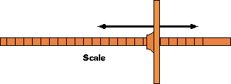
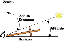
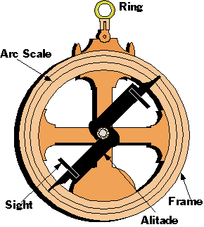
before Sextant and Chronometer. When the early navigators started venturing away from the sight of land they started developing methods of navigation involving the heavenly bodies. While not much is known about some of the methods we know there were several successful methods. The people that inhabited the south Pacific Islands were able to travel between islands using methods unknown to the Europeans. This is a list of some of the tools the european navigators used. The Astrolabe The astrolabe which means “star-taker,” was one of the oldest instruments used by astronomers but it did not serve at sea until around 1480. It was at this time the Portuguese drew up the rules for taking an altitude of the sun to establish latitude. The mariner's astrolabe was much simpler and cheaper than the astronomers version. Most were made of metal but some larger ones were made of wood for use on shore. It was probably invented by the Greeks. Astrolabes were used for surveying as well as astronomy. The scale read down from the zenith, 0° so the zenith distance was read directly. In northern latitudes an uncorrected sight of polaris could be read directly. There were many other scales related to astronomical work on these expensive instruments. Arabs crossing the deserts probably used one type of them long before they were used at sea. The instruments were hard to use in a heavy sea or in much wind. Later the English navigators preferred to use them for high altitudes (over 50°) and the cross-staff for lower latitudes. They had to be small (6 or 7 inches) and heavy (around 4 lbs.) in order to reduce the effect of the wind. The scales running from 0° to 90° scales were mirrored and used 0° for the horizon. They were cut by hand and often not too accurate. It could only be read to 1/2 a degree. Errors of 5° were not uncommon. |
 |
|
|
The Cross-Staff (Fore-Staff) The Portuguese in the 13th century found they needed a better method of obtaining an altitude. Astronomers aided Prince Henry the Navigator in developing the cross-staff. The instrument was cheap enough and simple enough for use at sea. The original ones consisted of a staff 30 - 36 inches long with a shorter moveable cross piece. The staff was held to the cheekbone and lined up with the horizon. The cross-piece was moved up and down the staff until the end of it was lined up with the star. The altitude was read off the staff. In the 16th century additional transversals (cross-pieces) were added along with extra scales on the staff. This gave the navigator the ability to get a larger range of angles. In the 17th century a “ brass sight” was added. This was a sight vane enabling the observer to use the back staff with his back to the sun. In the 18th century a piece of smoked glass was added to “temper” the sunlight when facing the sun. This instrument was used well into the 18th century as it was better for taking star sights than the back-staff. They may still have been aboard some early vessels on the coast. It was also much cheaper than the newer back-staff. . |
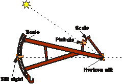
| The Back-Staff (Davis’ Quadrant) Back-Staff Around 1594 John Davis invented the back-staff for taking altitudes of the sun which was difficult to do with a cross-staff. The observer turned his back to the sun so it did not burn his eyes. The sun image was projected on to a horizon slit. The normal practice was to use the back-staff for sun sights and the cross-staff for star sights. It could measure angles up to 90 degrees. The scales were easier to graduate than the cross-staff hence more accurate. However it was more fragile and required more craftsmanship to build. The instrument had two scales and three vanes (some had four) on what looks like an A frame. The front vane mounted on the 60 degree arc had a pinhole that cast a shadow on the horizon vane. Shadow vanes were also used. The third vane on the 30 degree arc was lined up so as to get the suns image and the horizon. The front vane, on the 60 degree arc, was set to the expected altitude. This could be set roughly by looking through the instrument. The vane on the closer 30 degree arch was adjusted until the sun shadow was lined up with the horizon. The sum of the two readings gave the altitude. As with most instruments there were different versions produced. Some had a lens instead of a pinhole or shadow vane. Some worried the lens would cause distortion due to the difficulty of seeing the edge of the sun on the horizon vane. We would imagine that the lenses of the era might cause distortion. The lens could be used on a hazy sun while the pinhole could not. Some had a diagonal rather than the 60 degree arch. A movable arm with the pinhole was set with a thumbscrew. There were some built with mirrors so star sights could be taken. The 30 degree arc was graduated to 1’ while the 60 degree arch is graduated every 5 degrees Some had 2 scales for altitude and zenith distance. Some had shadow and pinhole vanes. The pinhole was a brass plate with a small hole in it. Overall length around 25 in.(640 mm). Seems to have been built from a variety of woods including mahogany, ebony, rosewood, fruitwood and boxwood (arcs). Tests were done by Gerald Forty in 1984 and 1985 to determine the accuracy of the instrument. It was quite accurate for a instrument of this type. Out of 322 sights the mean error was .06 of a minute. The sights were taken under good conditions and wind and a seaway would have reduced this figure. For more information see Journal of Navigation May 1986 |
 |
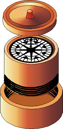
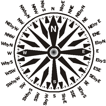
| Compass The compass allowed seafaring men to depart from the confines of the coast. Before the compass the vessel master had to rely on the stars to give him some idea of direction. The instrument seamen most depend on, whether deep sea or coastal, is the compass. The first ones were very crude. The exact dates of the development of the compass are shrouded in the fog of history. They were an iron needle floated on a basin of water. The needle had to be magnetized with a lodestone. While this procedure seems to have been used in the 15th century, some needles were mounted on a pivot as early as 1200. The needle still had to be stroked or “touched” by the lodestone. Sometime in the 13th century the needle was mounted under a card with a painting of a wind rose on it. The compass was mounted in a box and placed on a shelf. The needle could be refreshed with the lodestone from underneath. In medieval times some of the compasses were 4 or 5 inches in diameter. There were often two compasses in wood or brass boxes with a candle placed between them. The housing was called a bittacle. This was the forerunner of the modern binnacle. It seems that around 1500 the compass was mounted in gimbals. The magnetized steel bars mounted under the card arrived in the 18th century. Compasses were still fairly crude until that time. The practice of touching lasted through the century How to touch the compass needles - Moor 1796 "Having two strong magnetic bars, lay the compass needle as nearly north and south as you can, with the intended north end northwards, join the two magnets in a line, considerably above the needle, the north end being northward. and bring them down to the needle so the place of junction may be over it’s center,then draw them asunder along each half of the needle. Continue their motion till they are eight inches clear of the needles end. By a circular motion bring them again to the center and join them as before. Repeat this operation six or seven times, taking care not to put the magnets out of their parallelism, and the needle will be sufficiently Magnetical." Variation Of The Compass - Early 18th Century As compass accuracy was extremely important for the reckonings and there were no charts or tables giving the variation for most parts of the world the navigator had to take bearings of the sun or the N. star. 19th century Even after the variation was known and printed for some areas ships travelling in other areas worked out their own variation and kept a log of it. |
Early compass |
| THE MODERN COMPASS In 1768, (Captain Cook’s time) variation (difference between true north and magnetic north at the position of the ship) was understood. The compass, while sluggish, was a great improvement over earlier kinds. With the introduction of large masses of iron machinery and later iron hulls, a new problem arrived for the navigator. This was the compass error created by large amounts of metal. A number of misconceptions abounded. Some thought the compass was affected by fog, strong winds blowing in one direction, the Aurora Borealis, magnetic hills, shoals and thunderstorms. Although these were proven wrong, some of the opinions were expressed in this century. They also tried to shield the compass from the ship’s magnetism. Of course, if you were successful in this, the compass would not work. For years, there was not too much known about deviation and how to correct for it. This was one of the factors in slowing down the development of iron hulls. In 1801-02, Captain Matthew Flinders, R.N., while on a voyage to Australia discovered the use of a vertical, soft, iron bar reduced the effect of induced magnetism in soft iron. In 1838, Sir George B. Airy, started experimenting with the effect of iron hulls on the compass. In 1839 and 1855, he produced papers showing how deviation could be corrected by the use of magnets. The problems of deviation on ships are very complicated. In the earlier part of the 19th century, they frequently used large 18 or 20 inch compasses with long needles. These compasses were often sluggish. It was common to find a piece of marline attached to the compass bowl so the man at the wheel could give it a jerk to keep it alive, or “keeping the compass afloat.” It was found that smaller needles acted faster and if there was a light brass or aluminium ring around the outside, it was steadier. It was also easier to correct for deviation using small needles. |
|
| Lord Kelvin was a leader in this research. He produced the
first reliable admiralty compass. This was a dry compass using a light card
with an aluminium ring around its rim to dampen its movement. At one time, every seaman had to be able to “box the compass.” That is, recite all the quarter points going in either direction and what the opposite (180°) point was. Now the 360 degree card is in use so this is a lost practice. Later on, the liquid compass was introduced. The card was immersed in liquid with a flotation system on the card. The card was heavy enough to stay on its pivot. For many years the liquid was 45 per cent ethyl alcohol (non-drinkable) and distilled water. This was replaced by petroleum distillate in modern compasses. On all ships, a standard compass was located where the ship’s magnetism was least. This usually was on top of the wheelhouse (monkey’s island). A steering compass was located at steering station. At times, additional compasses were located in places where deviation would be low. All navigation is done using the standard compass when available. Tugs and small coasters usually did not have the luxury of a standard compass. At sea the compass could be checked with azimuths (bearings) of the sun and stars. Coastal vessels can check the compass by using ranges of known objects. This has an advantage of working when the heavenly bodies are obscured by low cloud. |
 |
Illustrations & story by R. Sheret
All photos, text and images belong to R. Sheret and Western Isles Photographics.
Home - Shop - Books - History - Marine Photographs