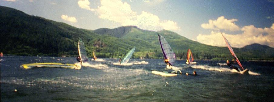
During the summer Nitinat Lake has some of the most consistent winds
in the world.
On a typical sunny day in the early morning there is no wind.
From about 10 AM to 11 AM you can look down the lake and see a wind line
and within 30 minutes the wind is 15 to 20 knots. As the day progresses
the winds will peak at around 2 PM to 3 PM at 25 to 30 knots.
On a really good day with a FOG BANK visible at the other end of lake winds
will be 25 to 40 knots. As evening approaches and the sun sets ,
the winds die down an usually stop, at which point you are usually totally
exhausted from shredding all day.
GETTING THERE
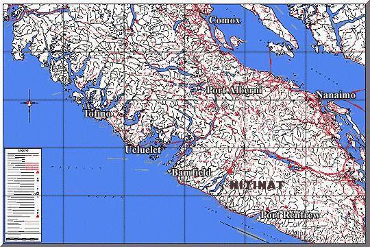
Nitinat Lake is located on the west coast of Vancouver Island.
It is about a 150 km drive from Victoria, B.C. which takes about
2 to 3 hours. The first 100 kilometres is main highway which takes
a little over an hour. If your driving from Victoria then take Highway
1 to Duncan, then take a left onto the highway to Lake Cowichan.
When you reach Lake Cowichan you have a choice of which side of Lake
Cowichan to drive. I usually take the North (right side) road to
Youbou which is where the pavement ends. The last 50 kilometres is
dirt logging road and takes about another hour to drive depending on how
fast you go. From experience I've found that the best speed to drive
the logging road is at 50 to 60 km/hr. If you drive faster than that
make sure you have really good tires or else there is a good chance that
you'll get a flat tire. Also make sure your spare tire is in good shape
and it's inflated. Also by aware the road is an ACTIVE LOGGING ROAD !!
The logging trucks that use this road are HUGE and take up over half the
width of the road. A couple of windsurfers have had there vehicles
"totaled" by one of these logging trucks and were lucky to live about it.
If you encounter a logging truck on this road then pull over as far as
you can to the side of the road and STOP. Wait for the dust to settle
before you continue because it is not unusual for other vehicles to be
following the logging truck. Once you're on the logging road follow
the (little signs with arrows) to Nitinat (Dididaht). First follow
the road to the end of Lake Cowichan (Heather campsite) then make a right
(or left if you came along the south side). Follow this road until
you get to a major T-Junction. If you take the right you'll end up
in either Bamfield or Port Alberni. Take the left road and in about 10
minutes you'll be at the village of Nitinat (Dididaht). Drive through
the village SLOWLY passing the motel, store (gas station). Soon after you
will come to a sign indicating the Macmillan Bloedel Forest Service campsite
road on the right. Take this road down to the campsite. If it's a
sunny weekend, then you'll have camp where you park, which is the tradition
here.
 Link
to Excellent Online Road Maps From Ministry of Forests
Link
to Excellent Online Road Maps From Ministry of Forests
Weather Forecasting Nitinat
Link to Current Weather at Nitinat Narrows (The south end of the Lake)
This weather station is at the ocean end of the lake. Windsurfing occurs at the north (river) end of the lake about 20 kilometres away, therefore the reported wind speeds are not a good indicator of what is happening at the windsurfing site. The wind directions are probably the best indicator. If the winds are southerly then inflow conditions are what is happening, which is good, since that is along the lake. If wind conditions are northerly then outflow conditions are occurring, which is an indicator that winds at the windsurfing site are shut down. If you watch the winds at this link on a good day winds should be northerly (outflow) in the early morning, then should switch to southerly inflow around midday. By the evening the readings should become light and variable and possibly outflow. If there are outflow winds in the mainland inlets and in the Strait of Georgia then an easterly flow is occurring over the region. This generally means that winds at Nitinat will shut off. The best times to go to Nitinat is when there is a good High Pressure ridge along the coast. This generally causes Northwesterly (inflow) winds along the west coast and is one of the main forcings that causes fogbanks. The high pressure ridge usually means its going to be sunny, which means the inland area of Vancouver Island heats up and the thermal inflow winds will kick in about midday.
A fog bank along the west coast of Vancouver Island is a really good
sign that Nitinat is going off.
The visible satellite photo should look something like the following.
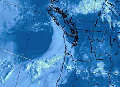 This is
a sample of what a good fogbank should look like.
This is
a sample of what a good fogbank should look like.
 Current 1km resolution Vis for Pacific NW
Note: Visible Satellite photos are of course only useable during daylight
hours.